
WAAS Navigation: What It Is, How It Works, and Why Pilots Love It
I remember the first time a fellow pilot told me about WAAS. We were sitting in a hangar after a bumpy IFR flight, and he said something like, “You’re still flying non-precision approaches? Get a WAAS-capable GPS and thank me later.” I thought he was being dramatic. He wasn’t.
So What Exactly Is WAAS?
WAAS stands for Wide Area Augmentation System, and it’s essentially a layer on top of regular GPS that makes the positioning data significantly more accurate. Standard GPS can be off by several meters. WAAS brings that down to less than three meters, which is a big deal when you’re flying an approach to minimums in low visibility.
You don’t pay a subscription. You don’t need a special license. If your GPS receiver is WAAS-enabled, you’re already benefiting from it.
How the Whole System Works
The mechanics are actually pretty elegant once you break them down. There are four main components:
- Ground Reference Stations: There are about 38 of these scattered across North America. They continuously collect GPS satellite data and note any errors they detect.
- Master Stations: These take all the data from the ground stations and crunch the numbers. They figure out exactly what corrections need to be made — things like ionospheric delays and small orbit errors in the GPS satellites themselves.
- Uplink Stations: Once the corrections are calculated, uplink stations beam them up to geostationary satellites.
- Geostationary Satellites: These satellites sit in fixed positions relative to the Earth and broadcast the correction signals back down. Your WAAS-enabled GPS receiver picks up these corrections and applies them automatically.
The whole process happens continuously, so your GPS is constantly getting updated correction data. It’s one of those things that works so well in the background that you almost forget it’s there.
Why WAAS Matters
Three big reasons. First, accuracy — getting your position down to under three meters is a game-changer for precision approaches and navigation in general. Second, integrity — the system monitors itself and tells you if something is wrong with the GPS signal. For pilots, that’s huge. You need to trust your instruments, and WAAS adds a layer of confidence that plain GPS can’t match. Third, availability — WAAS keeps GPS usable even in conditions where the raw signal might be degraded.
Where WAAS Gets Used
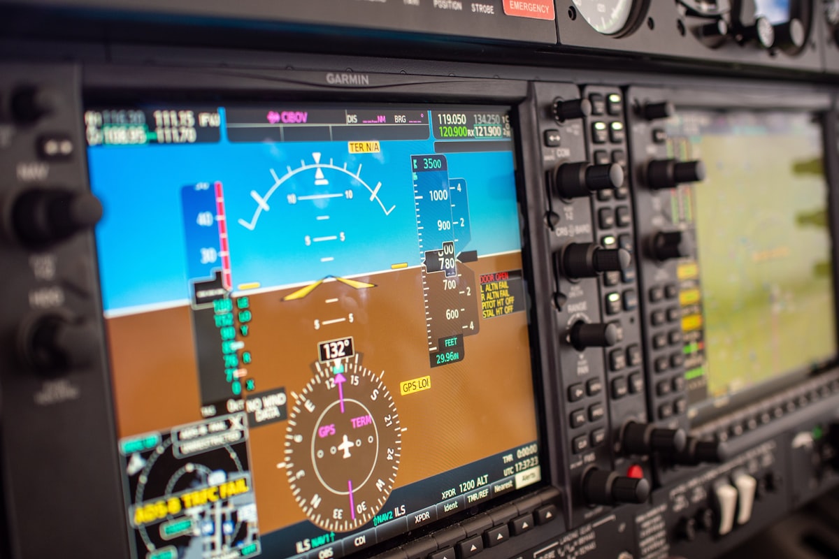
Aviation is the obvious one, and it’s where I’ve seen the biggest impact personally. WAAS enables LPV approaches — that stands for Localizer Performance with Vertical guidance — which give you approach minimums comparable to an ILS without needing ground-based equipment at the airport. For small airports that could never justify the cost of an ILS installation, this is enormous. It means better access in bad weather at thousands of airports that used to be VFR-only or limited to non-precision approaches.
But WAAS isn’t just for pilots. Farmers use it for precision agriculture — guiding tractors along exact paths for planting and spraying, which reduces waste and improves yields. Surveyors get more accurate measurements. Maritime navigation benefits from it. Search and rescue teams use WAAS-enabled devices when every meter of accuracy could mean finding someone faster.
WAAS Compared to Similar Systems Worldwide
WAAS covers North America, but other regions have their own versions. Europe has EGNOS (European Geostationary Navigation Overlay Service). Japan runs MSAS. India has GAGAN. They all work on the same basic principle — ground stations detect GPS errors, calculate corrections, and broadcast them via geostationary satellites.
The systems aren’t interchangeable though. Your WAAS receiver is designed for the North American corrections. If you’re flying internationally, you’d rely on the local augmentation system for that region.
Coverage You Can Count On
WAAS coverage blankets the continental United States, most of Canada, and parts of Mexico. In practical terms, if you’re flying anywhere in the lower 48, you’re covered. Coverage in Alaska and northern Canada is a bit spottier — or it used to be, anyway. They’ve been expanding and improving it steadily over the years.
And again, it’s free. That’s worth repeating. Some of the best technology in aviation doesn’t cost you a monthly subscription.
What’s Coming Next
The FAA and other agencies keep investing in WAAS improvements. As new GPS satellites go up — the GPS III constellation is a big deal here — the raw signal quality improves, and WAAS corrections get even better. There’s also work being done on integrating WAAS with other satellite navigation systems like Galileo and GLONASS for even more robust positioning.
Down the road, we might see WAAS-like performance supporting things like urban air mobility (think air taxis) and drone delivery networks, which need reliable precision navigation at low altitudes in congested areas. The foundation WAAS provides is going to be part of that future.
Limitations Worth Knowing About
WAAS is impressive, but it’s not perfect. In heavily forested areas or dense urban environments with tall buildings, GPS signals can get blocked or reflected, which degrades accuracy even with WAAS corrections. Ionospheric storms — which happen during solar activity — can also affect performance temporarily.
The infrastructure needs ongoing maintenance too. Ground stations, satellites, master stations — they all require monitoring and upkeep. It’s a big system with a lot of moving parts, no pun intended.
And there’s the dependency factor. If GPS itself ever goes down — whether from a technical failure or interference — WAAS goes with it. That’s why backup navigation methods still matter.
WAAS in Daily Life
Even if you never step foot in a cockpit, WAAS probably touches your life. If you use a GPS device for hiking or geocaching, it likely benefits from WAAS corrections. Fleet management systems that track delivery trucks use it. Location-based services on your phone can benefit from the improved accuracy. It’s one of those background technologies that quietly makes a lot of other things work better.
For Students and Researchers
If you’re studying GPS technology or satellite navigation, understanding WAAS gives you solid insight into how augmentation systems work across the board. Researchers in geophysics use WAAS data for studying ground movements. Meteorologists use it for atmospheric modeling. The precision and reliability of the position data make it useful across a surprising range of scientific fields.
Getting Set Up
Most modern GPS devices are WAAS-capable out of the box. Smartphones, car navigation units, handheld hiking GPS devices — many of them already support it. For aviation, you’ll want a certified WAAS GPS like a Garmin GTN or GNS series, or similar units from other manufacturers. Installation and certification for aviation use does involve some paperwork and cost, but the capability it unlocks is well worth it.
WAAS for Environmental Work
Wildlife researchers tracking animal movements get better data with WAAS. Conservationists mapping habitat boundaries produce more accurate maps. Environmental monitoring stations use WAAS-corrected positions for precise placement. When you’re tracking changes in an ecosystem over years or decades, those extra meters of accuracy add up to meaningfully better data.
WAAS and Emergency Response
During emergencies — search and rescue, natural disaster response, wildfire tracking — accurate location data can literally save lives. WAAS gives first responders better position accuracy for coordinating teams, locating victims, and assessing affected areas. When minutes count and you need to know exactly where someone is, sub-three-meter accuracy is the difference between finding them quickly or searching a much larger area.
For me personally, WAAS has been one of those technologies that, once you start using it, you can’t imagine going back. It just makes everything about GPS navigation more trustworthy. If you’re a pilot and you haven’t upgraded to a WAAS-capable GPS yet, seriously, go do it. That guy in the hangar was right.


Stay in the loop
Get the latest aviate ai updates delivered to your inbox.